

Introduction
The Info sheet on the main view provides real time information on your position and GPS status.
To open the Info sheet, tap on the Info tab at the bottom of the main view and the sheet will appear.
The sheet can be expanded and repositioned to see more information by tapping, holding and dragging the sheet by the grey bar at the top, up or down.
To close the Info sheet you can either drag the sheet to the very bottom of the screen, or tap on the Info tab again.
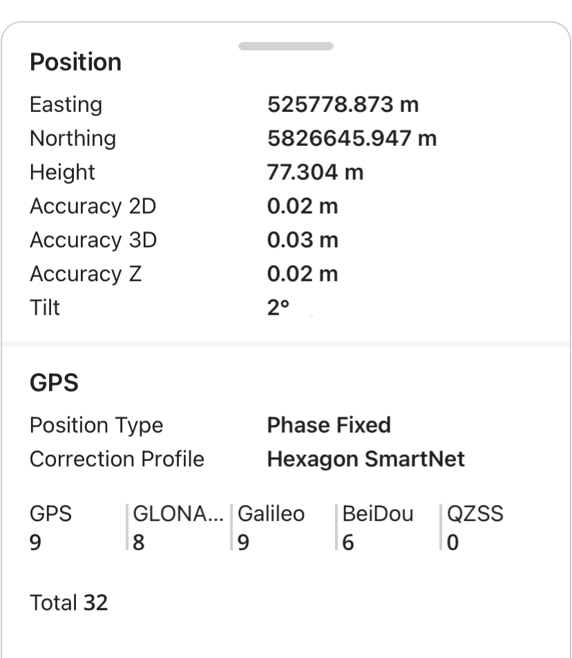
Position
X, Y coordinates
The coordinates of your GPS position are shown live at the top of the info sheet and are updated at a rate of 5 Hz when connected to a GPS antenna.
If your project is using a projected coordinate system then your X and Y coordinates will be shown as Easting and Northing in meters or feet (depending on the type of coordinate system used).
If your project is using a geographic coordinate system such as the default WGS84, then your X and Y coordinates will be shown as Latitude and Longitude in degrees, minutes, seconds decimal format.
Height
Your current height displayed will be orthometric if using a Geoid or defined separation. If you are not using a Geoid the height displayed will be ellipsoidal.
The units for height are displayed according to the coordinate system you are using.
If you are using a local projected coordinate system and have the Geoid set to None, then the height in the Info sheet will be in reference to the ellipsoid used in the coordinate system.
If in the same project you have layers that contain the ellipsoid height auto attribute, this value is always in reference to WGS84 and therefor the height may differ from that displayed in the info sheet if your coordinate system is using an ellipsoid different from WGS84.
Accuracy
The 2D, 3D and Z accuracy of your position is calculated by Zeno Mobile One using data from your GPS antenna. The accuracy unit displays according to the unit selected in the Settings menu.
Accuracy 2D is stated as DRMS (2D distance root mean square) meaning approximately 65% of measured positions fall within this radius of the true position. This is the same value that is shown in the measure button.
Tilt
When using a tilt compensating GPS antenna with tilt turned on, the amount of tilt used is shown in degrees.
If the tilt option is turned off ‘Tilt off’ is displayed instead.
GPS
The GPS section of the Info sheet shows information on which GPS correction profiles are selected and the status of satellites being tracked.
Position type
There are 4 different position types that can be displayed in Zeno Mobile One
|
Navigated |
The antenna is computing position from satellite signals alone, with no correction data. This is the lowest accuracy position type. If you are using the internal antenna of your device this is the only position type that can be achieved. |
|
Code |
Correction data is being received and applied to the coarse (code) measurements. and accuracy is generally sub-metre. If you are using SBAS as your correction profile this is the most accurate position type that can be achieved. |
|
Phase Float |
The receiver is using the more precise carrier-phase measurements but has not yet resolved them to a whole number of wavelengths. Accuracy is typically decimetre level and will continue to improve over time. |
|
Phase Fixed |
The carrier-phase measurements have been fully resolved. This is the highest accuracy position type that can be achieved. |
Correction profile
The correction profile shows the name of the current correction profile you have selected in the GPS Correction Profiles menu.
Satellite systems
The satellite systems your antenna is using are shown here.
The number of satellites per system is the number of satellites in use to compute your position.
It is possible to turn off particular satellite systems in the Active Satellite Systems menu. If a system is turned off, Off will be shown in the info panel under the applicable system name to indicate this.
The total is the total number of all satellites in use to compute your position.